Building on a rich history of research, scholarship, and teaching related to spatial topics, the University of Minnesota (UMN) has embarked on a visionary project to develop a collaborative consortium that supports the spatial sciences and creative activities. The project, U-Spatial, organizes researchers into an interconnected network of cores (thematic areas) and nodes (physical locations). U-Spatial helps eliminate duplication and fragmentation of scientific resources, and provides a framework of data, equipment, expertise, and resources that benefits all researchers working with spatial related sciences and creative activities. The need for infrastructure support for the spatial sciences and creative activities was registered for some years; the opportunity to build a broad-based infrastructure across traditional disciplinary and college boundaries has come much more recently.
The Need for U-Spatial
What were the factors that motivated the University of Minnesota to support the development of this large and extensive information infrastructure? First we should consider the national and international context. The spatial sciences are a broad and fast-growing field that studies spatiotemporal aspects of people, places, and processes using information technologies. They find wide-scale use in both traditional scientific fields and the humanities, ranging from data-mining climate data and understanding potential global warming impacts, to mapping historical ship registries to illustrate the growth of global commerce. It encompasses technologies ranging from satellite imaging, geographic information systems (GIS), computation technologies and social networks that rely on an infrastructure of communication. The U.S. Department of Labor identifies spatial technology alongside nanotechnology and biotechnology as the three most important industries in the 21st century. Based on information from the Geospatial Information & Technology Association, the Department of Labor predicts widespread and diverse uses, with the geospatial market growing at an annual rate of almost 35 percent (U.S. Department of Labor, 2010).
For over fifty years, the University of Minnesota has been a national and international leader in spatial-related scholarship and application development. Among many contributions, the UMN helped create one of the first geographic information systems, the Land Management Information System in the 1960s; we created the first professional degree program in GIS in the United States; and was where one of the key open-software packages for displaying spatial information was developed (Mapserver). Along with a long esteemed history in cartography, geodesign, and geography, we have a solid intellectual foundation in core disciplines ranging from computer science to remote sensing. The University has many internationally known spatial research centers, including the Center for Urban and Regional Affairs (CURA), the Remote Sensing and Geospatial Analysis Laboratory (RSAL), the Spatial Database and Spatial Data Mining Research Group, the Minnesota Population Center the Geographic Information Sciences Laboratory and the Polar Geospatial Center. A more comprehensive list of the units and people involved with spatial research can be found on the U-Spatial website.
Around 2006, we helped launch several efforts to develop a better understanding of the many uses of spatial technologies at the UMN. A survey was conducted that identified around 80 individuals working with geographic information technologies. A similar survey was conducted by the College of Liberal of Arts and established an equally large number of researchers who were using these technologies in the college. Survey respondents overwhelmingly identified needs for training, as well as support with finding and working with software and data. The survey results supported what people throughout the UMN had known for years--there are rich and diverse groups working with spatial research independently of each other.
The Geospatial Consortium, with attendees from various collegiate units and departments on campus, was an important step to the creation of U-Spatial. We began meeting to coordinate GIS software issues, but it quickly became apparent that there are plenty of campus-wide GIS issues that could benefit from greater coordination among units and so we broadened the group’s mandate to tackle a broader range of topics. The overarching mission of the consortium was to increase the presence, awareness and use of GIS and geospatial activities on campus. Participation in the Consortium was informal and open to anyone. The goals of the Geospatial Consortium included getting the word out on spatial activities on campus; meeting every semester to share information and discuss concrete steps to improve GIS on campus; and forging informal ties among people on campus. This was accomplished in part through maintaining the geospatial.umn.edu website and contributing to GIS Day, but there were other avenues including spin-off groups that focused on more narrow topics.
Making U-Spatial Real
The momentum to create a broader spatial enterprise at the UMN really took off in 2009. That January, with support from the Office of the Vice President for Research (OVPR), the Minnesota Geospatial Futures Symposium brought together researchers from across the UMN to discuss spatial topics. The Minnesota Futures Symposium was built on the efforts of the Geospatial Consortium and led to the creation of the document Geospatial Consortium: Collaborative Geospatial Activities at U of M. This document created the framework for U-Spatial and got people excited about the possibilities. The only piece missing from U-Spatial was start-up funding.
By 2011, there was a network of over 100 spatial researchers. A call for proposals from OVPR to develop infrastructures to support research and creative activities was the catalyst that mobilized this network. After preliminary discussions, a core group drafted a pre-proposal that was circulated in this network. The pre-proposal was successful and based on comments and many rounds of discussions, a full proposal submitted. The full proposal was successful and U-Spatial began with a combination of matching funds from 20 units and OVPR contribution totaling $2.5 million over five years.
Year One
U-Spatial is off to a great start in meeting our mission and having a very broad and substantial impact. Because of the size of the project and its need to establish governance practices among the large number of participants, we have taken a “soft-start” approach which involves the gradual development of U-Spatial services, while allowing for a more rapid development of support for existing research.
Collectively, U- Spatial offers four infrastructure cores: (1) Central Core services include technical assistance, training, resource coordination, and development of the spatial science community; (2) Imaging Core infrastructure focuses on data and analysis of aerial and satellite imagery of the earth; (3) Data Core initiatives include development of data discovery and archiving tools, as well as shared computing infrastructure; and (4) Analysis Core centers on spatiotemporal modeling, geodesign, and mapping (see Figure 1).
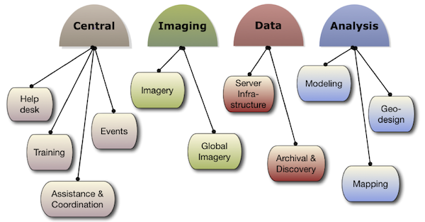
Figure 1: U-Spatial cores with activities
The diversity of projects within the cores is vast. For instance, RSAL is using satellite imagery to provide detailed maps of Minnesota landscapes and lake water quality, sharing this information with the world via a public website. The Geodesign group is creating a portable GIS system that will be used in public participation design and decision making; the system includes recording equipment to evaluate the process and interaction of participants in making decisions. CURA is creating a web map to allow for spatial searching of their projects, as well as providing training to researchers working in the North Minneapolis community. In Computer Science, U-Spatial is funding a graduate student working on the Planetary Skin Institute, an initiative which is developing resource management decision tools.
The Central Core has made good progress in addressing prime needs for a help desk and training. The help desk has assisted dozens of people with questions ranging from locating data to creating interactive web maps. The goal of the help desk is to be the first point of contact when someone needs help with a GIS or spatial technology question. If the help desk cannot answer a question, we can find an expert in the U-Spatial network who can. One example of a recent help desk request comes from ADAPT, a project “to learn about family resilience and to develop tools to support resilience among military families as they cope with the stress of deployment and reintegration.” (Family Social Science - ADAPT) U-Spatial is assisting by creating methodology to help geolocate and find central meeting locations for ADAPT participants; this involves researching appropriate methods, testing the protocols, and teaching ADAPT staff how to use the tools.
The Central Core regularly offers a popular GIS 101 workshop. This free, one-day workshop introduces participants to spatial analysis fundamentals, map making, and working with a popular GIS application. Over 400 people have taken the workshop already, which often leads to contacts with the help desk or further consulting projects involving U-Spatial.
We are also working to build the spatial research community at the UMN. There are hundreds of people working with spatial information at the University; the sharing of information is crucial for people to expand their skill and knowledge. This spring we started a GIS user group for people to get together and share ideas. Having a regular meeting will allow people to learn who else is working with spatial data on campus and create a network of expertise. Anyone currently associated with the University is welcome to participate in the User Group. That said, the person who will most benefit from the group is someone who regularly works with or supports people using GIS applications or spatial data. In October 2012, we will hold the first annual geospatial symposium based on the un-conference model to bring together spatial researchers from across the UMN.
A final area where the Central Core has focused effort can best be described as awareness raising, or marketing. The founding members of U-Spatial are highly advanced in their area of spatial research and for the most part, self-sufficient. But there are many colleagues at the UMN who could make use of U-Spatial and resources described above. To make these contacts, we have been attending a variety of seminars and workshops, as well as countless meetings to introduce U-Spatial. Growing U-Spatial participation is a first step towards making it sustainable beyond the five years of initial funding.
The process of developing an information infrastructure requires multiple years and broad involvement. Sustaining the development, in our experience, benefited from a small and dedicated group that was motivated to work through the myriad issues connected to collaboration that arise at any large university. We have also been fortunate to have received significant support from OVPR and the College of Liberal Arts in the stages that led to the successful U-Spatial collaborative proposal. Without their early (and continuing) support, it is not clear if we could have achieved what we have. With the continued and ongoing support of other U-Spatial participants we can still continue to support spatial related research and activities in the coming years.
A Sustainable Vision for U-Spatial
The vision for U-Spatial is the provision of key services to enhance research and creative activities involving spatial technologies. The Imaging, Data, and Analysis Cores have various research activities which U-Spatial helps to facilitate, but the major growth of these support services U-Spatial provides to researchers will focus in the Central Core.
The Central Core provides a help desk, training modules and community building for the University. The proposal for U-Spatial clearly situates these functions as services that allow researchers and scholars to more readily identify the resources they need for their research and allow them to point queries about fundamental issues to the U-Spatial help desk. We currently receive 2-4 queries for help weekly and we have every indication this number will increase, requiring us to recruit more research assistants. With a focus on support, we are soon going to develop resources that researchers regularly need, starting with research related frequently asked questions, universal access to software resources, web mapping capabilities, and help in preparing data management plans.
In addition to providing good help and other services, for U-Spatial to be sustainable, we will need to identify several layers of funding sources. On a large scale, we are actively participating with researchers throughout the UMN on securing outside grants. On a small scale, we provide GIS and remote sensing expertise to a growing number of research projects. Specialized training is also an area U-Spatial can provide excellent value. This diversified approach to funding, along with providing good value to participants within U-Spatial will ensure a sustainable initiative to fulfill its vision and visionary research and creative activities at the University of Minnesota.
References
Family Social Science - ADAPT n.d. http://www.cehd.umn.edu/fsos/projects/adapt/default.asp (last accessed 8 May 2012).
U.S. Department of Labor. 2010. High Growth Industry Profile - Geospatial Technology. http://www.doleta.gov/BRG/Indprof/geospatial_profile.cfm, (last accessed: 11 May 2012).